Those of us living here may wonder which of the many barrios in San Miguel de Allende warrants the title of “oldest neighborhood.” There is no question that San Miguel Viejo is the oldest settlement—it was the place in 1542 where the town began as a mission.

But what about the neighborhoods surrounding the Centro? Which one merits that designation?
According to historical records, the neighborhood of San José de la Montaña, roughly bordering on Atascadero, Balcones and Barrio de Tecolote, is the oldest outside of San Miguel Viejo. The area was originally settled by indios—natives—who built their houses on those hills, connected by tortuous streets that eventually were given Indigenous names such as Acampaxle, Cuitlahuac, Huitzlapochtli, and Cuahtemoc. 1 The entire barrio is a web of dead-end alleys, narrow passageways, corridors barely wide enough for a small car, and ridges that lead up and down steep slopes. Royal regulations imposed on the rest of San Miguel el Grande (the original SMA), required that roads be five meters wide, but that did not apply to the streets here; most in this barrio are only three meters side to side.
Another clue that this was indeed the oldest, indigenous populated area is that the original houses are only one story in height, unlike the two story mansions in the center of town, built by wealthy Spaniards. Neither will you find historical niches on the houses of this old indian barrio—those were introduced by Spaniards, carved into the buildings once the town of San Miguel was designated as a “Spanish town,” in which only Spaniards could live. The barrios de indios is where the natives lived; carving niches containing saints was completely foreign to them, and this type of adornment would not be something to put on a home that was barely a space with a roof over one’s head.

Laws enacted by the king of Spain regarding the colonies forbade the Spanish, mestizos, blacks, or Mulattos to live in the barrios of indios. An ordinance by King Philip II in 1563, explains why the mixing was forbidden: “Some Spaniards who deal, traffic, live and walk among the Indians, are restless men, of bad living, thieves, gamblers, vicious and lost people, and in order to escape being wronged, the Indians leave their towns and provinces…in addition to treating them [the natives] badly, make use of them, teach them their bad customs and idleness and also some errors and vices... we order that they be punished with serious penalties and not tolerate them in the Villa de San Miguel el Grande…” 2
The barrio of la Santa Veracruz Vieja, was founded in the 16th century as a town of Otomi indios, before the arrival of the wealthy Spanish landowners. Those natives, part of the original mission of San Miguel Viejo, who moved to the city’s current location, “established themselves in the Cruz Vieja” neighborhood, according to missionary and chronicler Felix de Espinosa Isidro (1679-1755). The various tribal groups settled in clumps, separate from each other, and isolated from outsiders because of the labyrinthine passageways without names where the inhabitants could disappear. Someone unfamiliar with the territory would be easily lost, and even today, with street names, it’s easy to get turned around in the neighborhood now called Barrio del Tecolote.
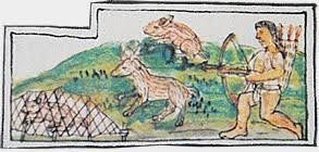
Below, Otomi natives are depicted doing some of the tasks and crafts they were known for, such as weaving, and hunting. The images are from the Florentine Codex—a 16th century ethnographic document of the indigenous people; compiled by Spanish Franciscan friar Bernardino de Sahagún.


Cuesta de San Jose was part of the original Camino Real de Tierra Adentro—the Royal Inland Road—traversed by mule trains that carried silver and gold from northern mines; as far north as Santa Fe, New Mexico. They traveled down into the town of San Miguel el Grande, then continued southward toward Mexico City, then to the port of Veracruz or Acapulco and hence to Spain or the Spanish colonies in the China Sea.
San Miguel el Grande was located along one of the branches of the Royal Inland Road, and the caravans frequently stopped to replenish supplies, and spend the night before continuing on their journey. The first inns—mesones—were built along the Cuesta de San Jose, and its continuation along Tecolote and Aparicio, which then turns into the true street of inns—Calle de los Mesones, or simply Mesones.
The production of leather goods was a major source of income for the residents of the town of San Miguel, and during the vice-regal period many tanneries sprang up in the neighborhood of La Santa Cruz Vieja. They discharged their residuum into the Arroyo de Santo Domingo, and that body of water became so foul smelling they called it “el arroyo hediondo”—the heinous stream.
A final indication that Cuesta de San Jose was part of the oldest route through town, is that uphill from the church, at the first intersection with Sierra Gorda was the Army Barracks. It was installed by the vice-regal government in the 16th century to house soldiers who protected the mule trains along the Royal Inland Road. The vestiges of that barrack still remain, a reminder that this was the entry into the town of San Miguel el Grande, where men with their mules carrying precious cargo would descend for an overnight stay, before continuing their journey south.
The designation of the oldest barrio is based on ancient plans provided by the Mexican government through its Secretaria de Desarrollo Urbano y Ecología del Estado de Guanajuato—Offices of the Secretary of Urban and Ecological Development of the state of Guanajuato, catalog 846, p. 23. The map includes parts of localities west of San Miguel el Grande, dated 1757.
C L Espinosa p 61

Comments